Cicli di dottorato attivi
- 41° Ciclo: Triennio 2025-2028
- 40° Ciclo: Triennio 2024-2027
- 39° Ciclo: Triennio 2023-2026
- 38° Ciclo: Triennio 2022-2025
- 37° Ciclo: Triennio 2021-2024
- 36° Ciclo: Triennio 2020-2023
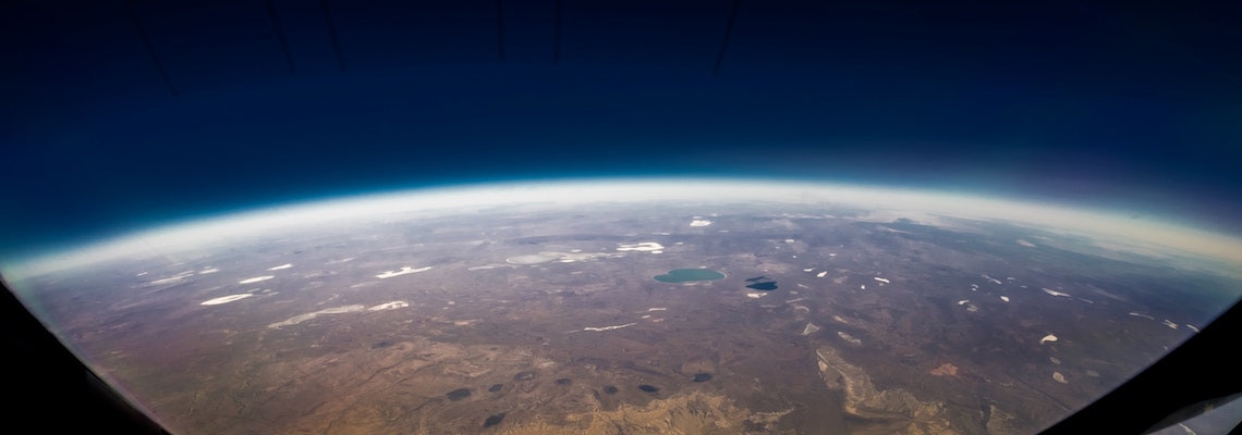
Planetary geology
This research theme focuses on deciphering the composition of Extraterrestrial Bodies (EB) through the quantitative comparison of their spectral features with spectral data of rocks of known compositions. The aim is to develop new research lines, through fundamental research activities, using a surgical approach integrating the experimental production of rock analogues, their spectral characterization, high-resolution data analysis and modelling of spectral data. Research will be carried out using the already existing experimental and analytical facilities complemented with the new equipment acquired using the funding deriving from the Progetto di Eccellenza Dipartimentale 2023-2027.
Analysis of hydrogeological and hydro-morphological processes in the context of climatic and anthropic variations
Ongoing climate change and anthropogenic pressures influence hydrogeological and hydro-morphological factors, such as aquifer recharge, surface runoff, erosion, riverbed and slope dynamics on a basin scale. There are many open problems concerning the management of surface water bodies and groundwater, such as hydro morphological alterations that may affect the interactions among groundwater and surface water bodies and slope dynamics. Moreover, the problem of the intensification of intense rainfall phenomena and the reduction of rainfall during the autumn-winter periods (recharge periods) may determine considerable effects on the recharge of aquifers and water availability. The project aims to integrate ground-based hydrogeological and hydro morphological approaches with remote sensing retrievals to assess the influence of climatic variations and water use on selected water systems in the Mediterranean area. The final objective of the research project is to mitigate the effects about which water body managers are concerned.
Data Science Applications and Modelling in Petrology and Volcanology
Data Science is becoming increasingly pervasive in any field of research, including Earth Sciences. By using advanced exploratory data analysis techniques, new modeling tools, machine learning, and big data, researchers can gain deeper insights into the evolution of magmatic systems, magma storage regions, subsequent magma migration events within the plumbing system, and eruptive dynamics. We accept proposals that aim at developing new data sciences applications in petrology and volcanology to better probe the evolution of volcanic plumbing systems and pre-eruptive dynamics.
Degassing in volcanic and tectonically active area: quantification, monitoring and risk assessment.
Volcanic, tectonically active and geothermal areas are characterized by the release of deep sourced volatiles, especially carbon dioxide. Characterization and quantification of the degassing is crucial for the comprehension of the source processes, of their dynamics, for the monitoring and for the evaluation of the impact of the degassing to the environments. This proposal is focused to the study of gaseous manifestations both in volcanic areas (e.g., Campi Flegrei) and in tectonically active areas (e.g., Northern and Southern Apennines) through developing a multidisciplinary approach integrating filed and laboratory measurements of geochemical composition of gases, direct measurements of diffuse and focused gas flux, concentration of the gases in air with numerical models of gas dispersion in to the atmosphere (e.g., Disgas and Twodee2) aimed to quantifying and monitoring the fluxes, to understand the evolution of the processes involved (unrest and volcanic eruptions, tectonic activity and earthquakes). The implemented methodology will also allow the estimation of the hazard associated with gaseous emissions, which represent a source of risk for human health and an impact on the environment in various natural contexts. Moreover, the developed approach finds application also in the prospection of geothermal resources. The PhD project will be carried out in collaboration with INGV.
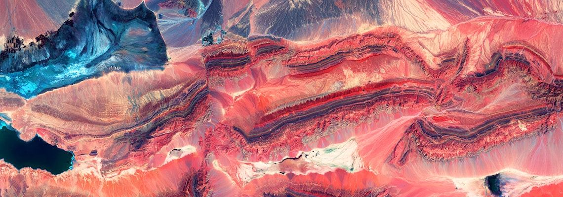
Faults, earthquakes and mechanical stratigraphy of the upper crust of the Italian peninsula
In regions of complex and recent tectonic activity, the uppermost crust, mainly consisting of sedimentary (or low-grade metamorphic) rocks, is characterized by a high grade of lateral and vertical lithological inhomogeneity, strongly affecting its rheology and mechanical behaviour and ultimately the earthquake distribution. Along the Italian peninsula and in the surrounding seas, different seismotectonic regions can be recognised, characterised by different types of causative faults, reflecting their complex present-day kinematics and the consequent state of stress. The research project is aimed to characterise the mechanical stratigraphy of the crust of these seismotectonic regions, collecting and integrating geological and geophysical data at different scales: regional and/or local geological maps and geophysical surveys (active and passive seismic, gravimetric, magnetic, thermic, etc..); well stratigraphy and logs from public and commercial sources; laboratory measurement of the mechanical, thermal and electrical properties on rock samples. The final objective will be trying to understand how the structure and the mechanical stratigraphy of the crust may influence the distribution of seismicity, the maximum expected magnitude and ultimately the seismic hazard of the studied regions. This workflow might be extended to other seismically active regions in the Mediterranean area and/or worldwide.
From industrial wastes to resources: decarbonization and circular economy.
The ecological transition is a necessary path towards sustainable development and one of the goals of the United Nations' 2030 Agenda. The concepts of decarbonization and circular economy are among the key points to ensure this. The present research proposal is dedicated to the development of strategies to improve the sustainability of industrial processes using geomaterials. The fine-tuned technologies will be optimized along the path of (i) decarbonization of production processes, (ii) ex-situ carbon storage and (iii) reuse of waste geomaterials that will reach the status of end-of-waste and become second-generation geomaterials. The characterization and optimization of waste feedstocks and products will be carried out using both in-house instrumentations, national/international facilities and collaborations with public and private laboratories/industries.
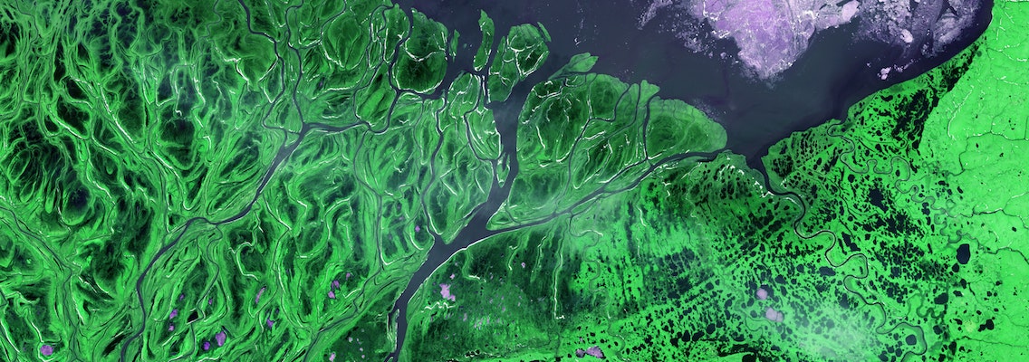
Geomorphological mapping on emerged and submerged lacustrine features and on alluvial landforms in a semi-natural environment
The research theme focuses on the study, recognition and mapping of lacustrine features both emerged and submerged and of drainage networks connected to them and subject to strong anthropization. The study case is the Trasimeno Lake (Umbria, central Italy) and the fluvial network with the adductors and emissaries connected to it.
The results will be used to update the legend of the Italian Geomorphological Map at a scale of 1:50.000 and the relative Geomorphological Database.
Geophysical characterization of Quaternary extensional basins in Umbria through microtremors: a contribution to seismic hazard assessment.
The Quaternary basins in Umbria (e.g., Gubbio, Colfiorito and Norcia) have been historically damaged by medium to high-intensity earthquakes. Several studies have attempted to address the stratigraphic and structural complexities that complicate both geological modeling at various scales as well as the determination of site response. Unfortunately, an accurate definition of the geometry of the basins and the hierarchy of the bordering active faults are still open questions within the scientific community.
During the study, that will be carried out in collaboration with national and international institutions, new and extensive passive seismic data will be acquired on selected sites in Umbria. Single-station measurements, as well as 2D seismic arrays will be used, and the data analyzed and interpreted together with already available geophysical, geological, and satellite data. The study goal will be the detailing the 3D basins architecture of the infilling Quaternary sediments. This work will be crucial for contributing to a better definition of seismic hazard and to reveal local ground motion amplifications.
Integrated platform/basin biostratigraphy (foraminifers and palynomorphs) across the “mid-Cretaceous”
This PhD project examines the changes in plant diversity and abundance during the Cretaceous (Aptian to Turonian), focusing on microfloristic and foraminifera analyses of key sections in the Umbria-Marche Basin and Turkey. The Cretaceous period was generally characterized by a warm, super-greenhouse climate with weak latitudinal temperature gradients and no ice sheets, although intermittent cooling periods were identified. The study aims to link vegetational changes to global environmental shifts, such as oceanic anoxic events triggered by massive volcanic activities. These events caused major disturbances in the carbon cycle and climate. Collaboration with national and international institutes will help improve temporal correlation and apply interdisciplinary approaches.
Marine response to climate changes during the Quaternary
Climate variability reflects the interactions between natural forcing and external forcing and has an important influence on the socio-economic development, ecological systems and human issues. For a better prediction and understanding of possible future climate evolution, it is essential to understand the mechanisms, causes, and amplitude of natural climate variability. Paleoclimate information facilitates understanding of Earth system feedbacks on time scales longer than a few centuries, which cannot be evaluated from short instrumental records. In this framework, the Mediterranean area is considered one of the most responsive regions to global change. In the Mediterranean area the effects of the climate change, likely supplemented by human activities, are rapidly transferred to the deep sea via an effective thermohaline circulation, pointing to the exceptional sensitivity of the coupled ocean and atmosphere dynamics to combined anthropogenic and natural climate forcing in the region. In this framework, planktonic foraminifera represent the most important tool for monitoring for paleoceanographic, paleoecological and sea-surface temperature reconstructions through the properties of their fossil assemblages or as a substrate for extraction of geochemical signals. The high abundance and the excellent preservation of planktonic foraminifera in marine sediment make them probably the best fossil record on Earth, providing unparalleled archives of morphological change, habitat and ecological variations.
Mineral physics for technological materials: new frontiers for the clean energy transition
The global transition to clean energy is accelerating demand for critical minerals, prompting the need to identify alternative, non-critical materials. A fundamental understanding of their mineral physics is key to enabling the development of high-performance materials for next-generation energy technologies. Mineral physics examines the behavior of materials at the atomic scale under extreme pressure and temperature conditions—environments relevant not only to the Earth's interior but also to advanced functional applications, such as superconductivity and materials with optical, magnetic, or energy-related properties.
This research focuses on the physical and chemical properties of emerging semiconductor and energy storage materials, particularly sulfosalts, hybrid perovskites, and high-entropy oxides. Their behavior under ambient and high-pressure/high-temperature conditions will be studied by using data from local laboratories and large-scale research facilities.
Sedimentary geology and sustainable resources - Alpine Tethys margins: basin architecture and stratigraphic evolution along an asymmetric rift system.
Stretching and thinning of the continental crust establish first-order geological domains characterized by specific stratigraphy and basin architecture. The Alpine Tethys magma-poor rift developed asymmetric margins characterized by specific geometric relationships (upper and lower plates), which flip along the rift strike. Understanding the distribution, timing, and depositional features of representative extensional basins formed during the onset of Alpine Tethys rifting is key to deciphering the three-dimensional structure of the margins. This project aims to examine the stratigraphy and thermal evolution of selected basins in the Alpine and Apennine ranges, which may help unravel the primary processes of similar magma-poor rifts formation at modern margins and is fundamental for the location and utilization of sustainable resources
Il dottorato in “Sistema Terra e Cambiamenti Globali”, istituito in occasione del 36° Ciclo, è focalizzato sulle tematiche riguardanti i cambiamenti climatici, la planetologia, le strategie di mitigazione dei rischi naturali e/o antropogenici, la domanda di risorse naturali, la valorizzazione del patrimonio geologico, paleontologico e paesaggistico e la sostenibilità ambientale. Questa missione si persegue anche offrendo alle giovani generazioni opportunità di formazione alla ricerca di alto livello, sia in ambito nazionale che internazionale. L’attività del corso e la sua offerta formativa poggiano innanzitutto sull’esperienza e la qualificazione dei membri del Collegio dei docenti, le cui ricerche hanno garantito costantemente l’attrazione di fondi assegnati su base competitiva, sia di carattere nazionale (es. PRIN, PNRA, PROGETTO DI ECCELLENZA DIPARTIMENTALE 2023-2027) che internazionale (es. ITN, ERC). I dottorandi possono inoltre giovare delle numerose collaborazioni attivate sia con qualificate istituzioni accademiche e di ricerca a livello internazionale, sia con Enti Pubblici di Ricerca di rilevanza nazionale (es. CNR, INGV, OGS, ASI) e con altri soggetti pubblici (es. ENEA, ISPRA, ARPA-Umbria, SABAP-Umbria, ecc.) e privati (es. ENI, ENEL, COLACEM, TIM, ecc.).
Il dottorato in “Sistema Terra e Cambiamenti Globali” forma esperti di elevato profilo tecnico-scientifico, in grado di inserirsi in diversi ambiti occupazionali, sia nel settore pubblico che in quello privato. Le competenze aggiornate ed innovative, caratteristiche di questo corso di dottorato, basato su un approccio spiccatamente interdisciplinare, accresceranno ulteriormente le opportunità di inserimento dei neo-dottori in diversi ambiti, quali: le istituzioni accademiche e gli enti di ricerca, nazionali e internazionali, che si occupano di Scienze della Terra; le agenzie governative che richiedono ricercatori in grado di supportare le decisioni di gestione e le politiche per affrontare alcuni dei maggiori problemi ambientali che la società moderna si trova oggi a fronteggiare, anche in un'ottica di sempre maggiore interazione tra operatori e comunità locali (licenze sociali); gli enti pubblici e le aziende che si occupano di (1) gestione del territorio e mitigazione dei rischi geologici, (2) reperimento, modellazione e gestione delle georisorse, (3) produzione sostenibile di risorse minerarie ed energetiche e (4) studio, tutela e valorizzazione del patrimonio paesaggistico e culturale.
L’attività didattica del dottorato ha il suo fulcro nel progetto di ricerca svolto dai singoli dottorandi, che saranno fortemente incoraggiati a personalizzare il proprio percorso formativo, al fine di conseguire la migliore formazione possibile nel loro settore di ricerca elettivo.
Per supportare al meglio la costruzione di tale percorso formativo, il dottorato mette a disposizione le migliori risorse didattiche disponibili all’interno del Collegio dei docenti e negli Atenei e centri di ricerca internazionali con i quali il collegio mantiene collaborazioni di ricerca, programmando ed attivando una serie di attività didattiche, che comprende insegnamenti specifici del dottorato, scuole e cicli seminariali.
Ogni anno, il Collegio dei docenti approva un percorso didattico composto da corsi, scuole e seminari.
I corsi sono specificamente progettati per il dottorato in “Sistema Terra e Cambiamenti Globali” e sono preferenzialmente rivolti ai dottorandi; sono tenuti da membri del Collegio dei docenti e/o ricercatori nazionali e internazionali con cui i membri del Collegio hanno relazioni scientifiche. Su richiesta, in base ai posti disponibili, i corsi possono essere frequentati da dottorandi di altre sedi, sia italiane che straniere. I corsi generalmente prevedono attività pratiche accanto a quelle teoriche. I corsi prevedono una verifica finale. Le scuole sono aperte sia ai dottorandi che ad altri partecipanti (es. studenti universitari o altro). La partecipazione a corsi e scuole è facoltativa (a eccezione del corso riportato sotto), in relazione, ad esempio, all’attinenza tra l’argomento del corso/scuola e quello del progetto del singolo dottorando.
I seminari sono organizzati in numero di 6-8 per Ciclo e sono tenuti da qualificati ricercatori italiani e stranieri, su tematiche attinenti a quelle del dottorato. I seminari si svolgono di regola nei mesi di gennaio–aprile. I dottorandi sono tenuti a seguire almeno il 75% dei seminari erogati per l’acquisizione di 3 CFU.
Nell’ambito dei 30 CFU obbligatori che ogni dottorando deve acquisire, 9 CFU sono dedicati a un corso multidisciplinare sulle tematiche del dottorato (Sistema Terra e Cambiamenti Globali). La partecipazione a questo corso è obbligatoria per tutti i dottorandi (al primo o secondo anno).
Una permanenza in una o più strutture estere (università, centri di ricerca o altre istituzioni di elevata qualificazione) di almeno 6 mesi (anche non continuativi) è fortemente raccomandata per tutti i dottorandi (obbligatoria per alcuni tipi di dottorato; es. PNRR, PON).
Il corso di dottorato promuove la partecipazione a corsi su tematiche trasversali organizzati da altri dottorati dell’Università degli Studi di Perugia o da altre università italiane e straniere, specie se di carattere multidisciplinare, transdisciplinare e interdisciplinare.
I dottorandi hanno possibilità di partecipare a corsi di lingua straniera presso il Centro Linguistico d’Ateneo (CLA) con durata semestrale o annuale. I corsi di lingua possono essere svolti, a scelta dello studente, nel corso dei tre anni, ma i CFU conseguiti non contribuiscono al raggiungimento dei 30 CFU che i dottorandi devono obbligatoriamente ottenere con le attività didattiche. I periodi di formazione all’estero, fortemente raccomandati per tutti i dottorandi, contribuiscono al potenziamento delle abilità linguistiche.